High-resolution soil moisture estimation using space-borne radar
Abstract
Satelliteborne C-band scatterometer measurements of the radar backscatter coefficient (σ0) of the Earth can be used to estimate soil moisture levels over land. Such estimates are currently produced at 25- and 50-km resolution using the Advanced Scatterometer (ASCAT) sensor and a change detection algorithm originally developed at the Vienna University of Technology (TU-Wien). Using the ASCAT spatial response function (SRF), high-resolution (approximately 15-20 km per pixel) images of σ0 can be produced, enabling the creation of a high-resolution soil moisture product using a modified version of the TU-Wien algorithm.
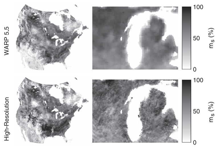
The high-resolution soil moisture images are compared to images produced with the Water Retrieval Package 5.5 algorithm, which is also based on the TU-Wien algorithm, and to in situ measurements from the National Oceanic and Atmospheric Administration U.S. Climate Reference Network (NOAA CRN). The WARP 5.5 and high-resolution image products generally show good agreement with each other; the high-resolution estimates appear to resolve soil moisture features at a finer scale and demonstrate a tendency toward greater moisture values in some areas. When compared to volumetric soil moisture measurements from NOAA CRN stations for 2010 and 2011, the WARP 5.5 and high-resolution soil moisture estimates perform similarly, with both having a root-mean-square difference from the in situ data of approximately 0.06 m3/m3 in one study area and 0.09 m3/m3 in another.
Citation
@article{lindell2016soil,
  title={High-resolution soil moisture retrieval with {ASCAT}},
  author={Lindell, David B and Long, David G},
  journal={IEEE Geoscience and Remote Sensing Letters},
  volume={13},
  number={7},
  pages={972--976},
  year={2016},
  publisher={IEEE}
}